Charlotte for the Non-Native:
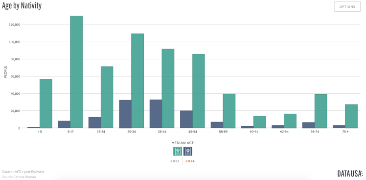
Many moving to Charlotte are within a certain age grouping, as the QC, or Queen City, is young in years and demographics. Over 35% of the population in the city is between the ages of 18 to 34 while over 25% of the population is between 35 to 55. The Downtown area of Charlotte reflects the youthful population as the numbers of bars, clubs, and business that aim to the ‘Millennial’ population.
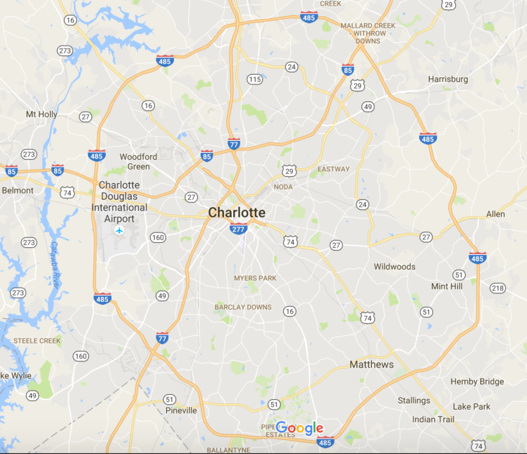
Geographically, Charlotte is divided into many districts, towns and suburbs. Some of these areas are wealthier and more well known compared to others, and for many natives the divide between the areas are classified by streets, neighborhoods and shopping plazas: Highway 51 cuts through South Charlotte until it hits the Aboretum Shopping Center, from there forward, most residents classify their hometown as Matthews, but after it hits Sardis, or even East John Street, the area is more commonly classified as East Charlotte. For non-natives, the easiest way to master the varying sectors of Charlotte are to observe the neighborhoods and districting of the Charlotte Mecklenburg School system. Charlotte is divided by the cardinal points, with a few exceptions such as Matthews, Mint Hill, and Pineville, which are suburbs of Charlotte but are also independent towns.
North Charlotte:
This area has seen the most gentrification relative to the other areas in places like NoDa, located on North Davidson Street, and the Northlake area, which border Lake Norman and Davidson. North Charlotte is home to the University of North Carolina at Charlotte, or UNCC, and thus the population reflects the demographics of the college, but North Charlotte does not identify purely as a college town, as UNCC entered a preexisting area, and much of North Charlotte is outside of the reach of the university culture. Other areas include North Tryon Street, Concord Mills, Sugar Creek, and Mallard Creek. North Charlotte is home to four high schools and a number of elementary and middle schools.
East Charlotte:
A more wealthy section of town, East Charlotte is no where near the affluence prominent throughout South Charlotte, but is one of the more recently renovated areas of Charlotte. East Charlotte includes sections of the Myers Park district, Cotswold, Sardis, Hickory Grove, and Idlewild. This area has the most expensive housing market relative to other areas of Charlotte and is home to six high schools, two or three also classifying as South Charlotte high schools as well.
South Charlotte:
Undoubtedly the most middle-class of all Charlotte suburbs, South Charlotte is home to the most lauded high schools in the CMS system, home to the wealthier citizens of Charlotte, and borders four independently identifiable areas: Weddington, Pineville, Union County, and Matthews. While these areas are by no means comprised of purely middle to high income citizens, the average annual income is greater in this areas relative to other Charlotte suburbs. South Charlotte is home to Ballentyne, Dilworth, Matthews, Quail Hollow, Piper Glen, Myers Park, Pineville, and Carmel. The wage gap in Charlotte is most distinct in this area as affluence is easily visible in the multimillion dollar homes, and the increased spending in infrastructure, education, and business development in these areas. Blakeney, Arboretum, Stonecrest, South Park Mall, Rea Road Shopping Plaza, etc., are places of commerce and wealth unrivaled in other areas of Charlotte, and are all located within the South Charlotte district. East and West Charlotte meld seamlessly into South Charlotte where they border, and the affluence in South Charlotte extends into South Carolina, touching upon the areas of Fort Mill, Rock Hill, Tega Cay, and Indian Land, with many of the affluent South Carolinians working in the Charlotte area.
West Charlotte:
The oldest of the four districts of Charlotte, West Charlotte is home to five high schools including West Charlotte High, the oldest high school in the CMS system. West Charlotte is most easily identified by its proximity to the Charlotte-Douglas International Airport, Gaston County, and the highways: I-485, I-77, and I-85. West Charlotte is relatively less wealthy than its southern and northern districts and shares a close proximity to the highways that connect Charlotte to the rest of the state and its neighbors, South Carolina and Virginia.
More history and information about these areas, the diversity within them, and the education systems will be provided in the Culture & History, Housing & Education, and Economy & Infrastructure sections of this website.
Charlotte Demographics and Poverty Levels
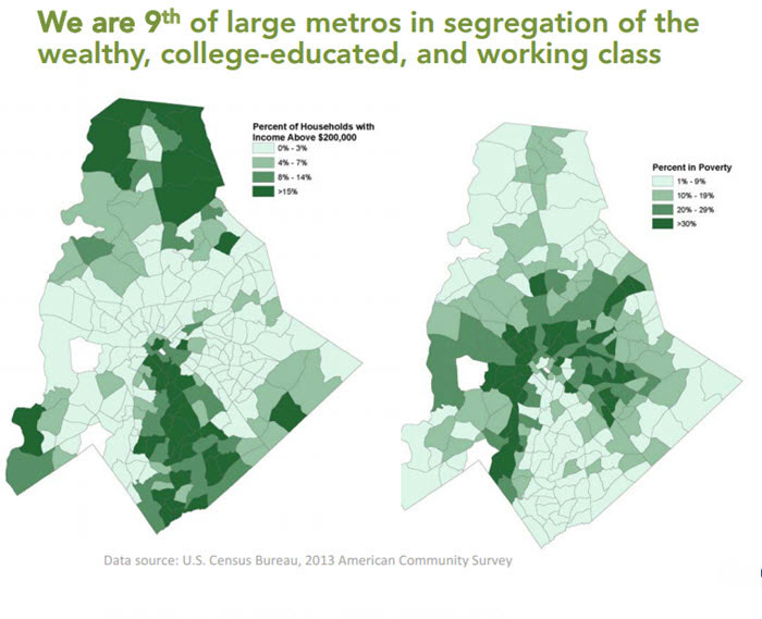
As you drive through Charlotte, or ride through on the sustainable and relatively inexpensive transit options, the gentrification scattered throughout Charlotte is rampantly visible. In this project, the proposals we suggest seek to eliminate this gentrification by allowing the native Charlotte populations, upper, middle, and low-income families, to have access to equal opportunities. While we recognize it is important to cater to the growing young professional class moving to Charlotte, it is equally important to remember the city’s roots and maintain strong economic equity among various socio-economic levels. For all of the growth that Charlotte has presented in the past decade, there is also great regression in various sectors of the economy. The infographic above indicates the segregation of education and poverty levels in Charlotte. Below are infographics from varying sources and varying years of data collection, an overall trend is present in the Charlotte-Mecklenburg area.
Social Movements in Charlotte:
There are a number of social movements throughout Charlotte and a number of websites that will provide information about the various sectors of Charlotte’s governance, economy, infrastructure and history.
- City Data: http://www.city-data.com/us-cities/The-South/Charlotte-Economy.html
- U.S. Census Bureau: http://www.census.gov/quickfacts/table/PST045215/3712000
- State of the South: http://stateofthesouth.org/north-carolinas-economic-imperative/
- Charlotte’s Got A Lot: http://www.charlottesgotalot.com
- Kid’s Count: http://datacenter.kidscount.org/data/bar/116-child-population-by-nativity?loc=1&loct=2#2/35/false/573/76,77/447
- Data U.S.A : Charlotte:https://datausa.io/profile/geo/charlotte-nc/
